Atmospheric Correction for Hyperspectral Remote Sensing
Why Atmospheric Correction Matters
Atmospheric effects significantly distort spectral signatures in airborne and spaceborne hyperspectral data. Water vapor, aerosols, and molecular scattering alter the reflectance signal between the surface and sensor, compromising material identification accuracy.
Atmospheric correction transforms at-sensor radiance into surface reflectance, enabling comparison with spectral libraries and consistent multi-temporal analysis.
FLAASH: Physics-Based Correction
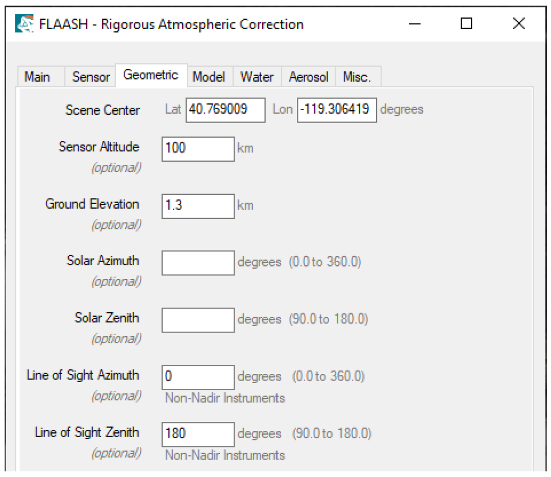
Fast Line-of-sight Atmospheric Analysis of Spectral Hypercubes uses MODTRAN radiative transfer modeling for rigorous atmospheric compensation.
Key Features
- Physics-based radiative transfer
- Water vapor and aerosol modeling
- Most accurate surface reflectance
- Automatic bad band identification
Required Parameters
- Scene center coordinates
- Sensor altitude
- Ground elevation
- Atmospheric model (Tropical, Mid-Latitude, Sub-Arctic)
- Aerosol model (Rural, Urban, Maritime, Desert)
When to Use FLAASH
- Final publication-quality analysis
- Maximum accuracy required
- Complete metadata available
- Sufficient processing time
QUAC: Rapid Scene-Based Correction
Quick Atmospheric Correction derives correction parameters directly from image statistics without ancillary data.
Key Features
- Scene-based empirical method
- No metadata requirements
- Fast processing
- Broad sensor compatibility
Requirements
- Spectrally diverse scene (10+ materials)
- Uniform illumination
- VNIR to SWIR coverage
When to Use QUAC
- Rapid assessment needs
- Missing metadata
- Initial data exploration
- Operational workflows
Empirical Correction Methods
Empirical Line Calibration
Matches image spectra to field-measured reference spectra using dark and bright calibration targets.
Requirements: Field spectrometer data, visible calibration panels
Best for: Small study areas with ground truth
Internal Average Relative Reflectance (IAR)
Divides each pixel by scene mean spectrum.
Best for: Arid scenes with spectrally flat dominant materials
Limitations: Poor performance with vegetation or urban areas
Flat Field Correction
Normalizes scene by mean spectrum of flat spectral region of interest.
Requirements: Identify spectrally flat ROI
Limitations: True spectral flatness rare in natural scenes
Dark Subtraction
Removes atmospheric path radiance by subtracting background value.
Best for: Reducing blue wavelength atmospheric scattering
Limitations: Limited correction capability, can amplify errors
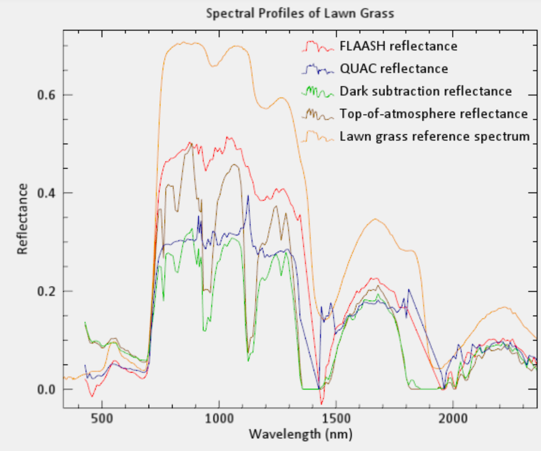
Method Selection Guide
| Criterion | FLAASH | QUAC | Empirical Line | IAR |
|---|---|---|---|---|
| Accuracy | Excellent | Very Good | Good | Fair |
| Speed | Slow | Fast | Medium | Very Fast |
| Metadata | Required | None | Field data | None |
| Complexity | High | Low | Medium | Very Low |
Decision Framework:
- Publication/research: FLAASH
- Quick assessment: QUAC
- Field validation: Empirical Line
- Desert geology: IAR
- Unknown conditions: QUAC (safe default)
Critical Preprocessing Steps
Remove Bad Bands
Water vapor absorption bands (1.4 μm, 1.9 μm) contain severe noise and must be removed before correction.
Identification methods: - Examine spectral profile plots for spikes - Use band animation for visual inspection - Check sensor specifications
Verify Data Type
- FLAASH input: Radiance
- QUAC input: Radiance
- Post-correction analysis: Reflectance
Quality Assessment
Visual Checks
- Atmospheric haze removal
- Vegetation red edge presence
- Water absorption features
- Smooth spectral curves
Quantitative Validation
- Reflectance range: 0.0 to 1.0 (snow may exceed)
- No negative values
- Spectral library correlation
- Known material verification
Common Artifacts
- Negative reflectance: Poor correction parameters
- Values > 1.2: Calibration errors
- Spectral spikes: Inadequate bad band removal
- Color shifts: Wrong atmospheric model
Best Practices
Workflow Optimization: 1. Remove bad bands first 2. Run QUAC for initial assessment 3. Use FLAASH for final analysis 4. Document all parameters 5. Validate with known materials
Parameter Selection: - Match atmospheric model to location/season - Select appropriate aerosol model - Verify sensor altitude accuracy - Use spatial subsets for large scenes
Conclusion
Atmospheric correction transforms raw hyperspectral data into calibrated surface reflectance suitable for quantitative analysis. Method selection depends on accuracy requirements, available metadata, and processing constraints.
FLAASH provides maximum accuracy through physics-based modeling, while QUAC offers rapid scene-based correction for operational needs. Empirical methods serve specialized applications with ground truth data or minimal processing requirements.
Contact
Email: mapcrafty@gmail.com
Subject: “Atmospheric Correction Consultation”